-
 Soil that's been burned in a wildfire often can't absorb substantial rainfall, sending water, mud and fallen trees downstream.
 -
 After the Dragon Bravo Fire burned the Grand Canyon's North Rim, there's an increased risk of dangerous flooding and mudslides.
 -
 Parts of the road were washed away in a 500-year flood in 2022.
 -
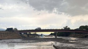
 New research shows that many rural roads in the Mountain West may be more vulnerable to flooding than people realize. That’s because the culverts and stream crossings underneath them aren’t built to handle today’s storms.
 -
 A new report shows tens of thousands of abandoned mines dot the U.S., including parts of the Mountain West. Experts say these sites pose pollution threats due to being in areas that are at high risk for flooding.
 -
 As the Trump administration considers a major overhaul of the nation's leading disaster relief agency, a new poll finds the majority of Americans think the government should help affected communities in Wyoming and across the U.S.
 -
 In recent weeks, destructive and deadly flash floods have hit several parts of the country, including the Mountain West. A New York Times analysis found the National Weather Service has vacant senior leadership positions at many offices overseeing areas vulnerable to flash floods.
 -
 The percentage of adults in the West who say they’ve been personally affected by an extreme weather event, including wildfires and high heat, jumped 13% in the last two years.
 -
 A new federal map shows nearly half of the U.S. could experience a landslide, and the risk is especially high across the Mountain West region.
 -
 Many of the counties with sizable Latino populations and elevated flood risks are in the West. The report recommends that government agencies invest in bilingual materials and community trust building, as well as infrastructure improvements and safe, affordable housing.

© 2026 Wyoming Public Media
800-729-5897 | 307-766-4240
Wyoming Public Media is a service of the University of Wyoming
800-729-5897 | 307-766-4240
Wyoming Public Media is a service of the University of Wyoming

Play Live Radio
Next Up:
0:00
0:00
Available On Air Stations


